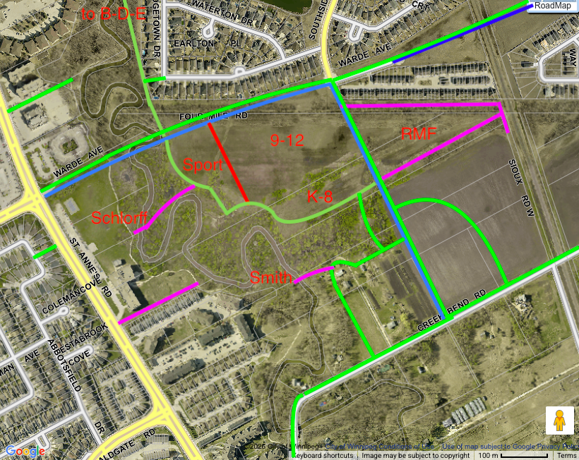
(KEY TO MAP CHANGES: Pink lines represent my personal blue-sky ideas, restoring two destroyed bridges, adding a path to try to make up for the thwarted Villas east-west trailhead (It is a long story as to how that trail was never built) and an AT path and nature corridor connecting to the CPKC Emerson Line. Green lines represent paths that the City would require (mandatory). Blue lines are public roads, of course.)
(ITERATION 3: In this version the east-west AT trail is consolidated along the joint Sampson/Qualico border. It incorporates the treeline that SOS originally tried to have Qualico save on their side of the border. It makes for a linear nature corridor. The AT trail no longer bisects the RMF area to the east and the school campus to the west.)
While public safety is currently top-of-mind for Creek Bend area residents, the Precinct K subdivision and rezoning (DASZ) process is still going on in the background. We have been told to wait for an invitation from Landmark Planning for a look at the latest iteration of their plans.
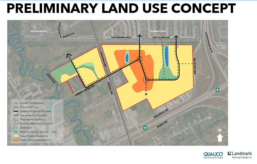
I have taken advantage of this vacuum to look at Qualico’s last proposal and see how they might integrate into any active-transportation plan for the Sampson Lands to their north.
The Sampson property is no longer listed for sale. Planners may be working on a DASZ proposal for the Sampson Lands as we speak
In their conversations with various Precinct K stakeholders Qualico Development and Landmark, its planners, have been honest in any discussions regarding building future public schools. There are legal consequences to them discussing potential school sites. Most importantly, they have been burned too many times by proposing school sites that the Province ultimately decided not to fund. (e.g. the Shorehill and Demetrioff school in Royalwood.) No Winnipeg developer will ever post a “Future School Here” sign in an empty field again.
The Louis Riel School Division is not as circumspect as they are in discussing potential new school sites. The LRSD has stated that it would eventually require a new school campus in Precinct K, preferably one built near Warde Avenue and the Seine River. It would like to build a new K-8 school and a new 9-12 high school, hopefully adjoining. On that basis, this gives the community permission to also conceptualize a new school campus in South Royalwood (I am sure the new name chosen for the community will be more original than that.)
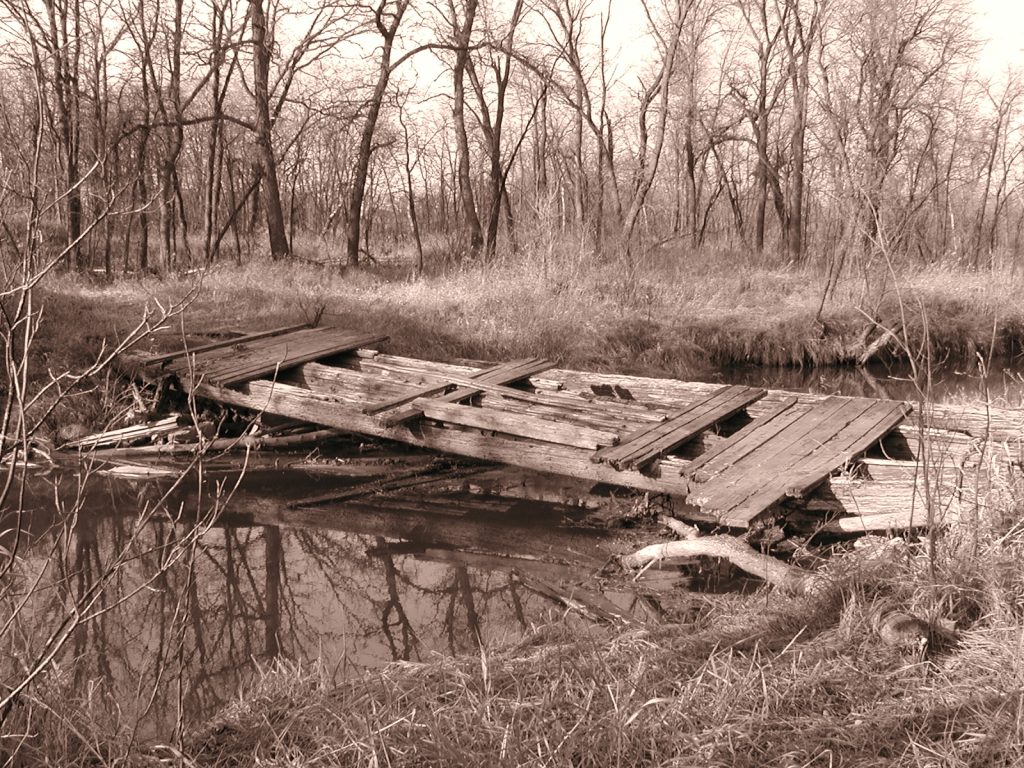
A LRSD campus as proposed on the east bank would mirror the DSFM high school campus already built on the western bank of the Seine. This would allow for synergies between the two solitudes, our two local school divisions. The wooden bridge over the Seine River formerly at the site, Schlorff’s Bridge (below), now demolished, could be rebuilt, once again linking the west and east banks of the Seine.
A new AT trail linking the South Seine River Greenway pathway to St. Anne’s Road on the DSFM property is also shown on my concept map.
Could trades and technology classrooms be made available to DSFM students? Could DSFM students share with LRSD students their language and their various cultures? Could the school divisions work together on joint conservation and river restoration projects?
The campus sports fields could be built above the east bank of the riverbank, allowing for a gentle buffered transition between built spaces and nature. The AT pathway could be integrated into the riverbank greenway, with gravel paths on top of bank and woodchips on the already existing monkey trails. (i.e. The old Schlorff family horse trails.)
The new sports fields could be retained by the Province or the land could be deeded to the City as PR lands for $1.
Efforts should be made to retain existing treed windrows and the treed Two-Mile Road right-of-way (used by Manitoba Hydro.) They would create an east-west trail system. While Qualico has pushed back on a green belt/AT pathway within its lands linking the river to the CPKC right-of-way, a series of closed loop trails could give the public destinations and recreational activities other than that of being smooshed on the railway tracks.
To date Qualico has been hesitant to show any actual pathways directly along the Seine River within its subject property. The proposed Qualico Smith Farm AT trails shown on their provided map are on lands east of the new Southside extension. Trail ROWs west of Southside are for discussion purposes only. The site of a second AT bridge, the restored Smith Farm bridge over the Seine, is also shown. (In a design charrette costs are not top of mind.)
As the City already owns the AT path right-of way top-of-bank from Warde ROW to Shorehill in existing Royalwood, the AT trail has been added to the map as a fait accompli.
I hope that this map engenders conversation and debate on best uses for the still vacant green-fields of South Royalwood.