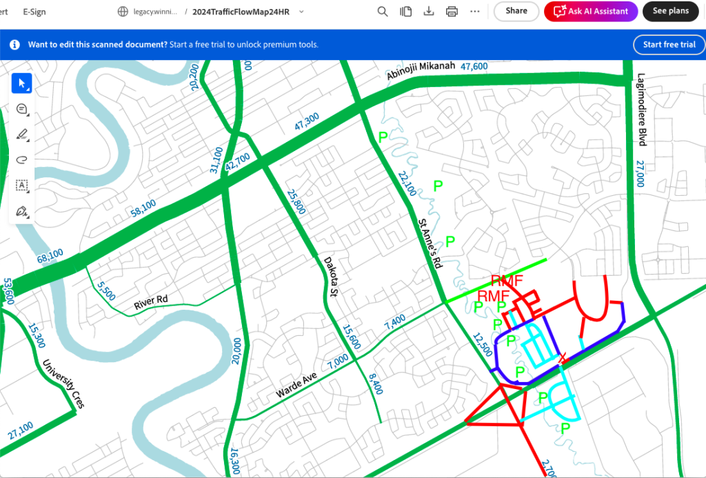
Imaginary Streets. Cheapest to build. Easiest to change. But even an imaginary street on a map may give us some clues to a future reality. What will SE Winnipeg look like in 30 years? Enquiring minds want to know.
Using my Cro-Magnon level computer skills, I played with the City’s 2024 regional street traffic count map. It does not even include the last phase of Bonavista, but it is the best map I found.
I put most of Qualico/Watersides’s proposed Precinct K streets in red on the map. I put the provincial St. Anne’s Road Perimeter Highway overpass on the map in red too. Existing streets I put in blue. Imaginary streets are aquamarine.
First, my apologies to my neighbours for putting imaginary streets in your yards. There is a reason that the City and planners don’t do that. It pisses people off. Mea culpa.
I also put streets in some of Qualico’s vast lands in St. Vital Perimeter South on the map, in particular in the famous Sumka Lands beside the Seine River. If I told you that the Sumka Lands are supposed to connect to Creek Bend’s Aimes Road via a new road beneath a new Perimeter Highway railway overpass, you probably would not believe me, but that is the plan.
Qualico and Save Our Seine like to pretend that that they do not foresee a new bridge over the Seine River connecting the Sumka Lands to St. Anne’s Road. If they want to do that, fine, but I put in a Sumka Bridge anyway. (Again, in aquamarine.)
Present or anticipated Seine River parks I marked with a green P. Everyone likes parks.
The Sampson Lands south of future Warde are slated for future Residential Multi Family (RMF) so streets aren’t necessarily needed to build new apartments and condos. This land will become a very high-density populated area.
While yesterday I looked at the micro, existing street widths, today I am looking at the macro, the City’s SE quadrant. I was told by the traffic engineers at WSP that they did not factor in any future development or any streets beyond those existing and those proposed by Qualico. They did not even factor in the Warde Avenue extension and the building of the Warde Avenue Bridge over the Seine.
The City is currently looking at the WSP traffic data. In 2014 the Creek Bend community was promised that Creek Bend Road would not become a collector street (over 5,000 cars per day.) Qualico has mostly done that, except for their new connection to Southside Drive, of course.
We were promised that Creek Bend would be a normal residential street, with less than 1,000 vehicles per day. That is predicated on the Warde Avenue Bridge being built, of course. Qualico’s subject DASZ application does not include a Warde Avenue Bridge.
While any streets shown in the Sioux Road West community south of Creek Bend are imaginary, this area is largely slated for low density residential housing. Only a small part of Sioux Road West is designated to become R1E Estate. The traffic counts currently in front of the City does not include any new housing or traffic from this area.
I think you know where I am going with this. If a resident in future Precinct K wants to go to the University of Manitoba, or if they simply want to access the traffic interchange at St. Anne’s Road and the Perimeter Highway, Creek Bend Road will always be an option. Delaying improving the local gravel street so that local residents pay to pave it, not Qualico, only delays the inevitable. Creek Bend Road will eventually need to be improved. The question is, who pays to actually do that?